|
20/05/2009
Prefecture of Kavala: Natural Environment
The geological relief is dominated by the massif of Pangaion Mountain, the gold bearing mountain of antiquity, in the western region, Symvolo Mountain in the northwestern part, parallel to Mt Pangaion, where the town of Kavala is located, Mt Ypsarion in Thassos and the Lekani Mountains in southeast. The terrain of the prefecture is mountainous at a percentage of 55%, semi-mountainous at 24% and flat at 21%. The plains of the prefecture are formed among the mountains. The most fertile and larger in size is the Chrysoupolis plain in the Nestos Delta. The most important water resource is the Nestos River, which borders the prefecture of Xanthi as a natural boundary from the straits of Nestos down to the Delta, and irrigates the Chrysoupolis plain.
|
|||||||
| |||||||
Audio-Video files | |||||||
| No audio or video files. | |||||||
Other files | |||||||
| No other files. |
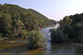 Nestos river
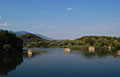 Nestos river
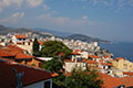 Castle view of Kavala